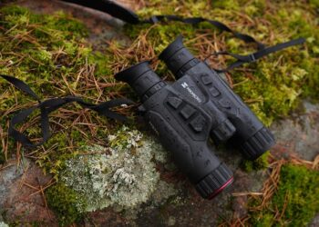
The Bushnell BackTrack D-Tour is a multifunction GPS, with which it will be possible not only to know your exact position, but also to record and archive the data stored while driving.
Any hunter who ventures into unknown places, from a geographical point of view, knows very well how important it is to know where you are going and how to get back. There are many GPS systems on the market that help find the way back. Each manufacturer offers products that differ from each other in terms of functions, technical and aesthetic characteristics.
Faced with such a wide range of GPS systems it can become difficult to make a choice as to which one to buy. With our articles we want to represent every single product without judging its functionality, and we limit ourselves to describing, in the best possible and accurate way, its technical characteristics, with the aim of helping the reader to "get an idea" of which one to choose.
What we are going to describe today is the BackTrack D-Tour, one of the new products recently put on the market by Bushnel, a well-known American company specializing in the production of optics for all uses, from hunting to leisure.
The BackTrack D-Tour is a GPS system with which anyone, in a simple and intuitive way, can find the way back from any place. Specifically, the BlackTrack D-Tour is a multifunction GPS. The function of registering the places we went to is combined with the possibility of downloading the routes on the "network" where it will be possible to archive them, analyze them and even share them on Facebook with their friends.
The BlackTrack D-Tour looks like a GPS very resistant to bad weather and atmospheric agents and is also equipped with the new GPS SiRF Star IV, which improves the reception of the GPS signal.
The BackTrack is considered by many experts as the perfect tool for those who want to keep track of their routes. In fact, it retains the signal for a long time even after the mobile phone has lost it, due to the absence of a signal.
With its 5 memorable points, the D-TOUR allows you to both save the paths and base camps visited, and to find the most hidden points. In addition to providing distance and direction to the places you are traveling to, the D-TOUR includes an auto-adjustable compass, an information system about route time, temperature, altitude and latitude / longitude coordinates.
The novelty inherent in this GPS is the ability to download route data for up to 48 hours to your PC or MAC, to relive and share your experiences with friends.
At just 170 grams and compact enough to carry in a pocket, the D-Tour can become the complete GPS system in all respects. Bushnell's BackTrack GPS allows you to memorize 5 different points along your route and tells us the distance and direction to follow to go back. It is able to memorize the position of the car in a crowded parking lot, the base camp, the starting point of excursions or to find the way back to your hotel in an unknown city.
Another feature of the BackTrack is the self-adjusting clock, temperatures and altitude. Each BackTrack D-tour and Point-5 has the particularity of automatically adjusting the time and provides information on the temperature in any place the excursion is taking place. This system is not to be underestimated, as we could imagine the great help it can provide when we visit places where the temperature range is strong.
As mentioned above, Bushnell's BackTrack D-Tour records up to two days of data covering hiking, biking, fishing and hunting. Whatever activity you want to record, your D tour can do it. At home you can easily download route data for up to 48 hours to your PC or MAC to relive and share your experiences. With the enhancement of the available data about the route, with the integration with Google Maps and with the sharing on Facebook, the D-TOUR application is the best way to record the tracks during your runs or excursions.
In such a sophisticated GPS system, the integrated digital compass could not be missing, which indicates the north in order to always let you know in which direction you are going. It also allows you to track the current latitude and longitude so you always know where we are.
At Bushnell we can say that they wanted to design and build a GPS as complete as possible, with a series of functions that make it useful and easy to use.
Below, as for each product, we report the technical characteristics of the BackTrack D-tour.
Vanguard stands out thanks to its consolidated experience in offering versatile solutions at the service of hunters and all countryside and nature enthusiasts. In their products we will find an entire range to cover all the needs of the different types of big game hunting...
In the vast panorama of hunting, technological evolution has always played a crucial role in improving the performance and effectiveness of the tools used by hunters. Among the most recent innovations that are changing the face of precision hunting is the introduction...
Hikmicro, a leader in digital optics, unveiled its latest innovation at the recent IWA Outdoor Classics 2024 event: the Hikmicro Habrok 4K thermal binoculars. This device promises to revolutionize the digital optics landscape thanks to its cutting-edge technical features,...
The wait for Italian shooters is over. Xero® C1 Pro, the high-precision pocket chronograph that until now has only been appreciated by the American market, is finally available in our country. The simplicity of transport, configuration and...
The stage of advanced technology and observation comes alive with Hikmicro's presence at EOS, and the company has no intention of going unnoticed. As usual, the brand will be present on the stand of the official distributor for Italy, Origin STB, in...
The Pulsar brand is known for its excellence in the production of thermal visors, presents its latest creation: the Axion XQ 35 thermal monocular. A concentrate of technology and innovation that promises to revolutionize the experience of outdoor enthusiasts,...
The Ranger 4S 4-16x44 from Steiner is the world's shortest and lightest hunting riflescope in its class, introduced as a new product for early 2024. With a magnification of up to 16x, it is the shortest riflescope on the...
When dealing with really long shots, the ballistics of normal rangefinders are no longer enough, because the trajectory of the projectile is also significantly influenced by parameters that have a negligible impact within the classic distances, such as for example the rotation of the axis...
The new Thermion 2 by Pulsar is a thermal riflescope that is easy to configure and highly effective. Under the thick cover of the forest, in an atmosphere suspended between silence and emotion, I had the opportunity to try the brand new riflescope.. .
In the field of hunting technology, thermal imaging has become an indispensable tool, revolutionizing the way hunters move through the wild. Among the pioneers of this sector is LIEMKE, a renowned brand that offers a wide range of...
Caccia Passione Srl
via Camillo Golgi nr. 1, post code 20090 Opera (MI) ITALY
CF and VAT number 08016350962
Newspaper registered at the Court of Milan nr. 17 of 20.01.2012 - ROC registration nr. 22180
Fully paid-up share capital € 10000
Chief Executive Officer Pierfilippo Meloni


